


In an astonishing scientific breakthrough, NASA’s latest satellite mission has revealed over 100,000 previously unknown seamounts—mountains hidden deep beneath the ocean’s surface. This groundbreaking discovery .What Are Seamounts and Why Do They Matter?
Seamounts are underwater mountains formed by volcanic activity. Though they never breach the ocean’s surface, their presence plays a crucial role in shaping marine ecosystems. These geological structures act as hotspots for biodiversity, influencing ocean currents, supporting fisheries, and serving as resting grounds for migratory marine species.
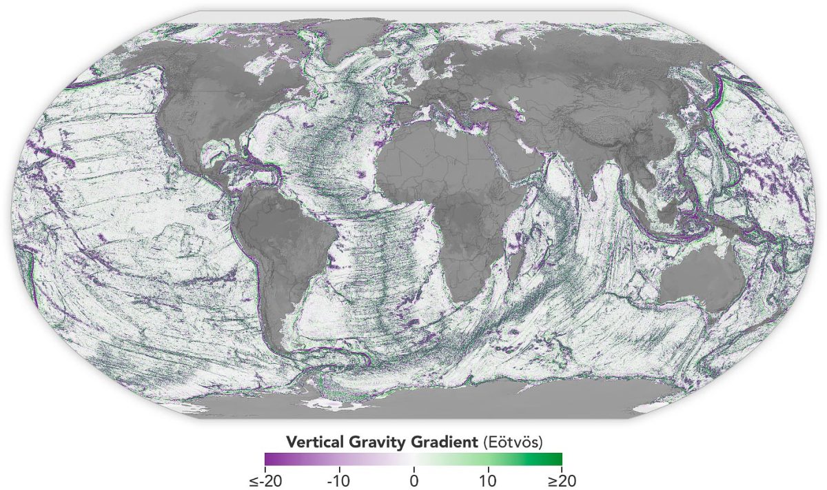
Until now, only about 25% of the ocean floor had been properly mapped, leaving vast areas of Earth’s largest ecosystem uncharted. With NASA’s new satellite technology, that’s rapidly changing.
The Technology Behind the Discovery
NASA’s Earth-observing satellite utilized advanced radar altimetry and gravity mapping to detect subtle changes in sea surface height—an indirect method that reveals the presence of submerged terrain.
Each seamount, though hidden under kilometers of water, creates a gravitational pull strong enough to cause a slight bulge on the sea surface above it. By analyzing these deformations with high-precision sensors, NASA scientists were able to identify and map over 100,000 new seamounts—a staggering increase to the estimated global count.
Implications for Science, Climate, and Marine Conservation
This monumental discovery is more than a cartographic feat—it’s a potential game changer for multiple scientific fields:
1. Climate Research
Seamounts influence deep-sea circulation and heat distribution across the planet. Mapping them helps climate scientists better model ocean currents, which play a critical role in global temperature regulation and carbon cycling.
2. Marine Biodiversity
These underwater mountains create unique ecosystems, acting as “underwater oases” for marine life. More accurate maps mean better protection for endangered species, improved regulation of fishing zones, and insights into marine evolution.
3. Tsunami and Earthquake Prediction
Seamounts are often found near tectonic plate boundaries, where volcanic and seismic activity is high. Improved mapping allows for enhanced models of tectonic movement, aiding natural disaster preparedness in vulnerable coastal areas.
4. Submarine Navigation and Deep-Sea Exploration
The updated maps are also vital for submarine operations, undersea cables, and upcoming deep-sea mining ventures. With accurate terrain data, the risk of underwater collisions is significantly reduced.
A New Age of Exploration
NASA’s findings come at a time when humanity is just beginning to scratch the surface of Earth’s final frontier—the deep ocean. With the discovery of these 100,000 new seamounts, scientists are calling it a “second space race,” but this time, the destination lies beneath our own planet’s waves.
This initiative also complements the global Seabed 2030 Project, an international effort to map the entire ocean floor by the end of this decade. NASA’s contribution brings us one major step closer to achieving that goal.
What’s Next?
The data collected will be shared openly with marine researchers, governments, and environmental organizations around the world. In the coming years, expect more collaborative expeditions to study the ecological and geological secrets hidden within these newly found underwater giants.
NASA’s satellite not only uncovered physical mountains—it elevated our understanding of the mysteries lurking beneath the blue expanse of our oceans. With this historic leap, we’re one step closer to a fully mapped, fully understood planet Earth.


+ There are no comments
Add yours